Kenya
Facts & Figures
-
President: Uhuru Kenyatta (2013)
Deputy President: William Ruto (2013)
Land area: 219,788 sq mi (569,251 sq km); total area: 224,961 sq mi (582,650 sq km)
Population (2014 est.): 45,010,056 (growth rate: 2.11%); birth rate: 28.27/1000; infant mortality rate: 40.71/1000; life expectancy: 63.52
Capital and largest city (2011 est.): Nairobi, 3.363 million
Other large city: Mombasa, 972,000
Monetary unit: Kenya shilling
National name: Jamhuri ya Kenya
Languages: English (official), Kiswahili (national), and numerous indigenous languages
Ethnicity/race: Kikuyu 22%; Luhya 14%; Luo 13%; Kalenjin 12%; Kamba 11%; Kisii 6%; Meru 6%; other African 15%; Asian, European, and Arab 1%
Religions: Christian 82.5% (Protestant 47.4%, Catholic 23.3%, other 11.8%), Muslim 11.1%, Traditionalists 1.6%, other 1.7%, none 2.4%, unspecified 0.7% (2009 census)
National Holiday: Independence Day, December 12
Literacy rate: 87.4% (2010 est.)
Economic summary: GDP/PPP (2013 est.): $79.9 billion; per capita $1,800. Real growth rate: 5.1%. Inflation: 5.8%. Unemployment: 40% (2008 est.). Arable land: 9.48%. Agriculture: tea, coffee, corn, wheat, sugarcane, fruit, vegetables; dairy products, beef, pork, poultry, eggs. Labor force: 19.3679 million; agriculture 75%, industry and services 25% (2007 est.). Industries: small-scale consumer goods (plastic, furniture, batteries, textiles, soap, cigarettes, flour), agricultural products, oil refining; aluminum, steel, lead; cement, commercial ship repair, tourism. Natural resources: limestone, soda ash, salt, gemstones, fluorspar, zinc, diatomite, gypsum, wildlife, hydropower. Exports: $6.58 billion (2013 est.): tea, horticultural products, coffee, petroleum products, fish, cement. Imports: $15.86 billion (2013 est.): machinery and transportation equipment, petroleum products, motor vehicles, iron and steel, resins and plastics. Major trading partners: Uganda, UK, U.S., Netherlands, Tanzania, UAE, Saudi Arabia, Egypt, India, China, Congo
Member of Commonwealth of Nations
Communications: Telephones: main lines in use: 251,600 (2012); mobile cellular: 30.732 million (2012). Broadcast media: about a half-dozen large-scale privately owned media companies with TV and radio stations as well as a state-owned TV broadcaster provide service nation-wide; satellite and cable TV subscription services available; state-owned radio broadcaster operates 2 national radio channels and provides regional and local radio services in multiple languages; a large number of private radio stations broadcast on a national level along with over 100 private and non-profit provincial stations broadcasting in local languages; transmissions of several international broadcasters available (2014). Internet Service Providers (ISPs): 71,018 (2010). Internet users: 3.996 million (2009).
Transportation: Railways: total: 2,066 km (2008). Roadways: total: 160,878 km; paved: 11,189 km; unpaved: 149,689 km (2008). Waterways: none specifically (the only significant inland waterway in the country is the part of Lake Victoria within the boundaries of Kenya; Kisumu is the main port and has ferry connections to Uganda and Tanzania) (2011). Ports and terminals: Kisumu, Mombasa. Airports: 197 (2013).
International disputes: Kenya served as an important mediator in brokering Sudan's north-south separation in February 2005; Kenya provides shelter to an estimated 550 million refugees, including Ugandans who flee across the border periodically to seek protection from Lord's Resistance Army rebels; Kenya works hard to prevent the clan and militia fighting in Somalia from spreading across the border, which has long been open to nomadic pastoralists; the boundary that separates Kenya's and Sudan's sovereignty is unclear in the "Ilemi Triangle," which Kenya has administered since colonial times.
Index
- Kenya Profile
- History
- News and Current Events
Geography
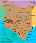
Kenya lies across the equator in east-central Africa, on the coast of the Indian Ocean. It is twice the size of Nevada. Kenya borders Somalia to the east, Ethiopia to the north, Tanzania to the south, Uganda to the west, and Sudan to the northwest. In the north, the land is arid; the southwest corner is in the fertile Lake Victoria Basin; and a length of the eastern depression of the Great Rift Valley separates western highlands from those that rise from the lowland coastal strip.
Government
Republic.
History
Paleontologists believe people may first have inhabited Kenya about 2 million years ago. In the 700s, Arab seafarers established settlements along the coast, and the Portuguese took control of the area in the early 1500s. More than 40 ethnic groups reside in Kenya. Its largest group, the Kikuyu, migrated to the region at the beginning of the 18th century.
The land became a British protectorate in 1890 and a Crown colony in 1920, called British East Africa. Nationalist stirrings began in the 1940s, and in 1952 the Mau Mau movement, made up of Kikuyu militants, rebelled against the government. The fighting lasted until 1956.
Kenya Wins Independence After a Long Struggle
On Dec. 12, 1963, Kenya achieved full independence. Jomo Kenyatta, a nationalist leader during the fight to win independence who had been jailed by the British, was its first president.
From 1964 to 1992, the country was ruled as a one-party state by the Kenya African National Union (KANU), first under Kenyatta, and then under Daniel arap Moi. Demonstrations and riots put pressure on Moi to allow multiparty elections in 1992.
Economic Woes, Corruption, and Disasters Stifle Development
The economy did not flourish under Moi's rule. In the 1990s, Kenya's infrastructure began disintegrating and official graft was rampant, contributing to the withdrawal of much foreign aid. In early 1995, President Moi moved against the opposition and ordered the arrest of anyone who insulted him.
A series of disasters plagued Kenya in 1997 and 1998: severe flooding destroyed roads, bridges, and crops; epidemics of malaria and cholera overwhelmed the ineffectual health care system; and ethnic clashes erupted between the Kikuyu and Kalenjin ethnic groups in the Rift Valley. On Aug. 7, 1998, the U.S. embassy in Nairobi was bombed by terrorists, killing 243 and injuring more than 1,000. The embassy in neighboring Tanzania was bombed the same day, killing 10.
In a successful effort to win back IMF and World Bank funding, which had been suspended because of Kenya's corruption and poor economic practices, President Moi appointed his high-profile critic and political opponent, Richard Leakey, as head of the civil service in 1999. A third-generation white Kenyan, son of paleontologists Louis and Mary Leakey, he had been a highly effective reformer as head of the Kenya Wildlife Service. But after 20 months, during which he made a promising start at cleaning up Kenya's corrupt bureaucracy, Leakey was sacked by Moi. Kenya is regularly ranked among the ten most corrupt countries in the world, according to the watchdog group Transparency International.
An anticorruption law, sponsored by the ruling party, failed to pass in Parliament in Aug. 2001 and imperiled Kenya's chances for international aid. Opposition leaders called the law a cynical ploy meant to give the appearance of reform; the proposed law, they contended, was in fact too weak and full of loopholes to make a dent in corruption.
Hopes for Reform Under New Administration Are Dashed
Opposition leader Mwai Kibaki won the Dec. 2002 presidential election, defeating Moi's protégé, Uhuru Kenyatta (term limits prevented Moi, in power for 24 years, from running again). Kibaki promised to put an end to the country's rampant corruption. In his first few months, Kibaki did initiate a number of reforms—ordering a crackdown on corrupt judges and police and instituting free primary school education—and international donors opened their coffers again.
But by 2004, disappointment in Kibaki set in with the lack of further progress, and a long-awaited new constitution, meant to limit the president's power, still had not been delivered. Kibaki's anticorruption minister, John Githongo, resigned in Feb. 2005, frustrated that he was prevented from investigating a number of scandals. In July 2005, Parliament finally approved a draft of a constitution, but in Dec. 2005 voters rejected it because it expanded the president's powers.
A drought ravaged Kenya, and by Jan. 2006, 2.5 million Kenyans faced starvation.
Ethnic Violence Follows Disputed Presidential Election
Kenya descended into violence and chaos following Dec. 2007's presidential election. Preliminary results had opposition candidate Raila Odinga, of the Orange Democratic Movement, defeating incumbent Kibaki, 57% to 39%. In the days after the election, however, Odinga's lead dwindled and Kenya's electoral commission declared Kibaki the winner, 46% to 44%. International observers said the vote was rigged. Odinga, a champion of the poor, had promised to eliminate corruption and tribalism. After the announcement of the official results, violence broke out among members of the Luo and Kikuyu tribes. Odinga is Luo, and Kibaki is Kikuyu. The fighting between the tribes intensified in Jan. 2008, with more than 800 people dying in violence across the country. Odinga refused Kibaki's invitation to discuss the political crisis after Kibaki appointed his cabinet, which did not include any members of Odinga's Orange Democratic Party. Parliament, however, did elect Kenneth Marende, of the Orange Democratic Party, speaker over an ally of Kibaki. The deployment of the Kenyan military did little to stem the brutal ethnic fighting. In late January, Melitus Mugabe Were, a member of Parliament who has worked to mend the ethnic strife in Kenya and help the poor, was dragged from his car and shot. Members of the opposition said the killing was a political assassination.
By Feb. 2008, more than 1,300 people had died in the ethnic violence. Former UN secretary general Kofi Annan met with representatives from the government and the opposition in an attempt to resolve the crisis. After protracted negotiations that left Annan frustrated, the government and the opposition agreed in late February on a power-sharing deal that has Odinga filling the newly created position of prime minister and the two rivals dividing cabinet positions. Parliament met in March, a much-needed first step toward restoring peace to the battered country. Kibaki announced an enormous national unity cabinet in April that includes 94 ministers. His supporters head powerful ministries, such as finance and foreign relations. As expected, Odinga was named prime minister. Power sharing quickly proved difficult, and the legislative process has been hampered by infighting accusations on both sides of corruption. A draft constitution published in November 2009 diminished the role of the president, making it a mostly ceremonial position, and devolved power to regional leaders. The constitution also includes provisions for land reform, establishes a bill or rights, and includes a system of checks and balances. By a margin of about 2–1, voters approved the constitution in an August 2010 referendum. The vote was split on ethnic lines; the Luo and Kikuyu tribes largely approved the referendum, and the Kalenjin, proponents of former president Daniel arap Moi, voted against it. The peaceful vote signaled that Kenyans are eager to return to stability.
Despite international pressure, Kenya refused to establish a special tribunal to investigate the post-election violence. In November 2009, the International Criminal Court announced that it would launch a formal investigation to determine if crimes against humanity had been committed in the violence.
On August 4, 2010, a new constitution passed by a wide margin. The new constitution included a bill of rights, transferred more power to local governments, and eliminated the office of prime minister. The new constitution went into effect on August 27, 2010.
Kenyan Forces Invade Somalia to Fight Islamist Militants
On October 16, 2011, Kenyan sent several hundred troops into battle against the Shabab militant group. Armored trucks, tanks and helicopters were also sent. Helicopters bombed Shabab bases. More Kenyan troops were sent in later with the goal to clear the Shabab out. It was a rare aggressive act by a country known for its laidback foreign policy. The act came as a surprise to the United States, an ally of Kenya. The U.S. had no advance knowledge of the invasion.
The Shabab, an insurgent group, has killed scores of civilians, carried out numerous suicide bomb missions and sworn their allegiance to Al-Qaeda. The Kenyan government justified its invasion, blaming the Shabab for a series of recent kidnappings in Kenya.
Four Prominent Kenyans Charged with Crimes against Humanity
In January 2012, four well-known Kenyans were ordered to stand trial at the International Criminal Court in The Hague. The four men were charged with crimes against humanity for their roles in the violence that erupted after the disputed 2007 elections. More than 300,000 people were forced to leave their homes and at least 1,100 people were killed in the violence.
One of the men brought up on charges was Uhuru Kenyatta, the richest man in the country and the son of Kenya's first president. Former education minister and Kenyatta's political rival, William Ruto, was also charged. Both Ruto and Kenyatta said they would run in the next election, regardless of the court's ruling. Radio executive Joshua arap Sang and cabinet secretary Francis Muthaura were the other two men charged. No trial date has been set, but the presidential election is expected in late 2012 or early 2013.
Kenyan Troops Storm Somalian Port City, Oust Militant Group
Shabab was dealt a severe blow in September 2012 when several hundred Kenyan troops, with the help of Somalis, took over Somalia's port city of Kismayu in an amphibuous assault. The incursion followed several weeks of air and naval assaults by Kenya on key Shabab positions in Kismayu. The city was the last Shabab stronghold, and the militant group used the port to bring in weapons and raise money by charging hefty import fees. The incursion was uncharacteristically brazen, and Kenyan officials said it had to protect its citizens from violence on the border. In addition, Kenya's economy was being adversely affected by the turmoil in neighboring Somalia caused by the Shabab.
2013 Presidential Elections Largely Peaceful; Charges Against Kenyatta Dropped by ICC
As the 2013 presidential election approached, many feared a repeat of the deadly violence that plagued the disputed 2007 race and left about 1,300 dead. Those fears did not play out in the tight race between top contenders Prime Minister Odinga and Uhuru Kenyatta, the richest man in the country and the son of Kenya's first president. In the March election, Kenyatta won 50.07% of the vote to Odinga's 43.7%, narrowly enough to avoid a runoff. Kenyatta and his deputy president, William Ruto, were two of four men charged by the International Criminal Court in 2012 with crimes against humanity for their roles in the violence that erupted after the 2007 elections.
In Dec. 2013, the International Criminal Court case against President Uhuru Kenyatta experienced a severe blow when the prosecution revealed that they had lost two key witnesses. One witness had given false evidence and another was no longer willing to testify. Fatou Bensouda, the prosecutor, said that she needed more time to prepare new evidence. After months of delays, Kenyatta appeared in court in early October 2014 when judges held hearings on how to proceed with the case. Kenyatta is accused of obstructing the ICC's investigation into the violence. He is the first sitting head of state to be brought before the International Criminal Court in The Hague. The ICC dropped the charges against Kenyatta in December 2014, citing a lack of evidence. Bensouda accused the government of obstructing the investigation. The trial of Vice President William Ruto will continue.
Somalian Militants Terrorize Luxury Mall and University as They Continue to Target Non-Muslims
Deputy President William Ruto pleaded not guilty to charges of crimes against humanity at the International Criminal Court in early September 2013. The charges stem from the violence that followed the 2007 election. President Kenyatta is scheduled to appear before the court in November. Days before Ruto appeared at the ICC, parliament voted to withdraw from the court.
Members of Al-Shabab, an Islamic militant group that is allied with al-Qaeda and based in Somalia, attacked an upscale mall in Nairobi beginning on Sept. 21, 2013, killing nearly 70 people and wounding about 175. The siege lasted for several days, with persistent fighting between government troops and militants. The attack was meticulously planned, and the militants proved to be challenging for the government to dislodge from the Westgate mall. Shabab, based in Somalia, said the attack was in retaliation for the Kenyan military's role in helping Somalia battle the militant group. In the wake of the violence, the ICC suspended the trial of Ruto so he could return to Kenya and assist in managing the crisis.
Over the course of two nights in June 2014, the Shabab slaughtered at least 65 non-Muslims in Mpeketoni, a town near the resort island of Lamu. Most of the victims were members of the Kikuyu tribe—the one to which Kenyatta belongs. Although Shabab claimed responsibility for the massacres, saying they were in retribution for the recent shooting of three radical Muslim clerics in Mombasa, Kenyatta said his political opponents carried out the attacks. Tourism has plunged amid the ongoing violence.
The Shabab continued its campaign against non-Muslims throughout 2014. In attacks in November and December, the group killed more than 60 people in remote villages.
On April 2, 2015, Shabab militants attacked Garissa University College in northeast Kenya. In a daylong siege, the militants separated Muslims and non-Muslims, sparing Muslims. The non-Muslims were taken hostage and more than 140 were killed. Security officials freed the surviving hostages and killed the four gunmen. In a statement, Shabab said the attack was a planned "operation against the infidels." In response to the slaughter, Kenyan military jets bombed two Shabab camps.
Barack Obama Visits Kenya

U.S. President Barack Obama visits Kenya, 2015
Source: Ben Curtis for ASSOCIATED PRESS
In July 2015, Barack Obama visited Kenya for the first time since he became president of the United States. His father, Barack Obama, Sr., was born in Nyang'oma Kogelo and returned to Kenya in 1964, after he graduated from Harvard. Obama, Sr. lived in Nairobi at the time of his death in 1982. Kenyans have seen President Obama as a long-lost son and treated him as such during his 2015 visit, including welcoming ceremonies and lines of people holding signs greeting him wherever he went.
While there, President Obama was at odds with President Uhuru Kenyatta over human rights, including issues such as same-sex marriage. Under Kenyan law, sexual activity between men is illegal. "When you start treating people differently not because of any harm they are doing to anybody, but because they are different, that's the path whereby freedoms begin to erode," Obama said during a joint press conference in Nairobi. President Kenyatta responded, "There are some things we must admit we don't share, our culture, our society don't accept. It is very difficult for us to be able to impose on people that which they themselves do not accept."
Despite the disagreements, President Obama kept the focus on his personal history with the country, having visited Kenya three times before he took office. During a speech at a business forum while there, he said, "I'm proud to be the first U.S. president to visit Kenya, and obviously, this is personal for me. There's a reason why my name is Barack Hussein Obama. My father came from these parts and I have family and relatives here. And in my visits over the years, walking the streets of Nairobi, I've come to know the warmth and the spirit of the Kenyan people." President Obama also made an effort to repeatedly praise the country's democratic progress and economic growth.
See also Encyclopedia: Kenya .
U.S. State Dept. Country Notes: Kenya