Weather: The Connection Between the Sea and the Atmosphere
The Connection Between the Sea and the Atmosphere
So how does something in the ocean influence the atmosphere? We already saw how hurricanes depend on the sea for energy, but there's more. The sea and air are really connected, each influenced by the other, with the same dynamics occurring in both. The sea and atmosphere are both fluids; they differ in terms of density. Sure the sea is a thousand times more dense than the air, but that doesn't separate them. The sea and atmosphere come together at an interface.
Weather-Speak
El Nio is a name given to a periodical warming of equatorial ocean water. It disrupts weather and causes all kinds of havoc—from droughts to floods and landslides.
Waves and surface currents are wind-generated. The atmosphere pushes the ocean surface along. But as the ocean moves, heat is redistributed and eventually tossed back into the atmosphere. The exchange of heat influences the pressure field in the atmosphere, which modifies the wind field. The first figure below shows how this exchange and feedback take place.
The heat exchange often occurs in storms when water evaporates from the surface. Hurricanes feed on that transfer, and most storms receive at least some energy from the process. The water vapor carries away the ocean heat, and then, when condensation occurs, the borrowed heat is released into the atmosphere. In general the oceans contribute more than two thirds of the heat balance of the atmosphere in mid-latitudes. Without the oceans, our weather would be unearthly.
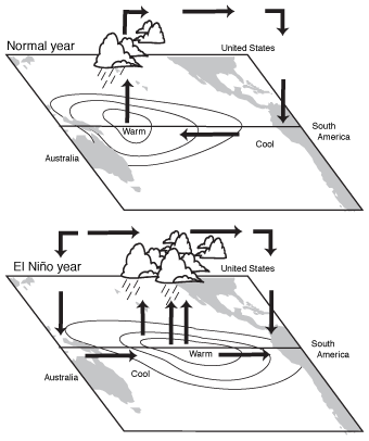
Ocean-atmosphere feedback.
In the case of El Nio, the impact can be worldwide. The second figure shows the temperature departure from normal during El Nio periods. Strong El Nios can raise water temperatures by as much as five to ten degrees in a huge area extending from the central Pacific to the west coast of South America, which the big El Nio that occurred in both 1983 and 1998 did. Other El Nio currents only elevate sea surface temperatures by two to four degrees, but even that can influence the atmosphere. The additional heat in the eastern Pacific feeds into the atmosphere. Tall cumulonimbus clouds appear. The energy delivers a strong jet stream that races northward from the tropics: a subtropical jet stream. It's always present, but it strengthens during El Nio years. The jet stream turns into the United States and even pushes through the Atlantic.

El Nio water temperature changes.
At the same time, in response to that motion, a strong area of low pressure appears in the North Pacific. It, too, is always present, but during an El Nio it shifts farther south. These shifting wind patterns dramatically alter the weather in the Northern Hemisphere. Floods, rains, and massive surf pound the West Coast. Floods and tornadoes rake the lower Midwest while balmy winters settle into the Northeast. At the same time, hurricanes are deflected from their normal paths. The following figure shows the changes that take place.
El Nio causes shifting wind patterns in the atmosphere, but other shifting wind patterns get El Nio going in the first place. El Nio is a perfect example of atmosphere-ocean feedback.
Here Comes the Kid
Normally winds blow from the east in the tropics. These are called trade winds. But occasionally the pressure difference in the atmosphere across the Pacific will change. Higher pressure than normal builds across the western Pacific. Because the air flows from higher to lower pressure, the typical east-to-west flow will weaken and possibly even reverse. The air will move from high pressure to low and, in this case, from west to east.

Atmospheric flow with El Nio.
That atmospheric motion pushes the warm surface water eastward. It bumps into the west coast of South America and drifts southward as a warm current. Water temperatures off the coast will normally be in the mid-70s, but when El Nio arrives the temperature jumps into the mid-80s. The water level rises in the eastern Pacific by as much as one foot. In the western Pacific, the water drops by a foot. Where the water level drops, the water is much cooler than normal because the surface water has been blown away. When El Nio is at its peak, strong high pressure will be present in the western Pacific with lower pressure to the east. At the same time, colder water will be in the western portion of the ocean with warmer water in the east.
Typically, after several months, El Nio begins to self-destruct. The warm subtropical high pressure in the western Pacific weakens as lower air temperatures develop from the exchange with the colder ocean surface. That west-east flow has no choice but to diminish. Also, like coffee in a cup, the water that piled up in the eastern portion of the Pacific basin sloshes back to the west. The warm surface water leaves the eastern Pacific and shifts west. The water temperature lowers off the coast of Peru and Ecuador. The pattern completely reverses. The technical name for this back-and-forth phenomenon is the El Nio Southern Oscillation (ENSO). The dynamics that lead to El Nio and its demise are shown in the figure below.
Weather-Speak
There are two separate belts of steady winds found between latitudes 23.5 degrees, north and south. They marked popular sailing routes for commercial sailing vessels and appropriately were called trade winds.
Both the 1982 to 1983 and the 1997 to 1998 ENSO events showed striking similarities. Both were extreme with ocean surface temperatures differing from normal by 10 degrees or more. Each appeared during the spring when the easterly trades weakened. West of the International Date Line, winds shifted and came out of the west during May.

El Nio oscillation.
Within the next few weeks, the ocean began to respond to the wind shift with sea level rising a few inches at Christmas Island in the mid-Pacific. By autumn, sea level rises of up to a foot occurred as far east as Ecuador. Likewise, sea level dropped in the western Pacific. Coral reefs were exposed near many of the Pacific islands. By January, ENSO had peaked and seemed to show few signs of reversing. But, amazingly, by late spring and early summer, cold water appeared where great warmth had earlier prevailed. The change had occurred.

Excerpted from The Complete Idiot's Guide to Weather © 2002 by Mel Goldstein, Ph.D.. All rights reserved including the right of reproduction in whole or in part in any form. Used by arrangement with Alpha Books, a member of Penguin Group (USA) Inc.