Weather: Storms on the Front
Storms on the Front
The weather within air masses is generally quiet, except when another opposing air mass comes along and challenges it. Then the fronts, with their ability to lift the air, generate a variety of weather. But these air-mass boundaries are not quite finished with us. Because of the density difference near fronts, medium- or synoptic-scale motions come into circulation. These atmospheric swirls can easily cover 500 to 1,000 miles. Half the United States can be enveloped by one of these systems. Because the air is rising and being drawn away, the pressure is relatively low, and these become typical low-pressure systems. They are technically called frontal cyclones because they spin counterclockwise and form along fronts. The common, everyday storm system is a frontal cyclone. The key source of energy here is that density difference across the front. Once these low-pressure areas form, they generate their own characteristic weather.
Weather-Speak
A frontal cyclone is a storm that forms on a front. In the Northern Hemisphere, it has a counterclockwise circulation and covers an area of several hundred miles, occasionally up to one thousand miles.
Formation and Life Cycle
The following figure shows how these frontal cyclones kick in. Usually, two high-pressure systems are locked in place—one north of a stationary front and the other south of the front. Because the air moves clockwise around high-pressure systems in the Northern Hemisphere, the wind is coming from the east just north of the front and from the west just to the south of the front. Picture yourself holding a pencil between both of your hands. If one hand moves in one direction and the other hand moves the other way, then that pencil will be set into motion. The air near the stationary front is just like that pencil. In the configuration of the next figure, the motion would be counterclockwise. A small, counterclockwise circulation forms and makes the front look wavy. These little waves form all the time, but only occasionally do they grow into a rip-roaring storm. Something else is needed.
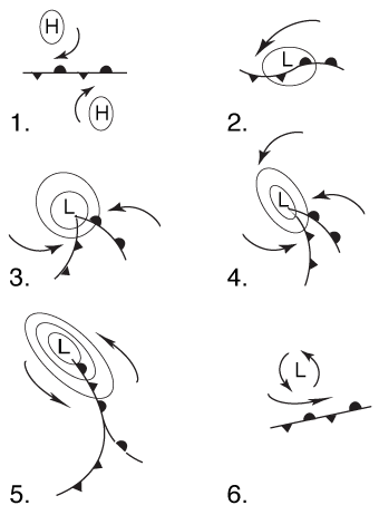
Formation of frontal cyclone.
Weather Words
"When descends on the
Atlantic
The gigantic
Storm-wind of the equinox,
Landward in his wrath he scourges
The toiling surges,
Laden with seaweed from the rocks."
—"Seaweed," Henry Wadsworth Longfellow
The upper atmosphere to the rescue! For a variety of reasons, the air above one of these waves could be diverging—drawn away. Strong wind differences at levels of 18,000 feet in the atmosphere can account for this divergence. The strong flow acts as an exhaust fan. When that exhaust takes place, the pressure is lowered near the ground, on the front, and in the vicinity of the wave. The pressure drops in that wave and, because of the greater pressure difference, circulation increases. It then becomes a major low-pressure area—a major rain- or snow-maker.
The circulation causes the stationary front to move. A portion of it becomes a cold front. Another portion turns into a warm front. So not only will the low-pressure system's upward motion help generate stormy skies, the fronts will deliver their own meteorological mix.
In the northeast quadrant of a frontal cyclone, the weather will be typical of what precedes a warm front—drizzly, rainy, foggy, sometimes icy or snowy. In the northwest quadrant, there is more of the same, except the air is colder, and snow is most likely here—thanks to the north wind. In the southeast quadrant, the weather is typical of what follows a warm front and precedes a cold front. In the southwest quadrant, the weather is similar to that which occurs following a cold front passage. This distribution marks the mature stage of the storm.
Eventually the cold front will catch up with the warm front—as you've learned, they always move faster. The temperature contrast across the frontal cyclone then weakens, losing some of that potential energy, so the storm eventually weakens. That is called the occluded phase because an occluded front forms.
Of Nor'easters and Sou'westers
These storms are special frontal cyclones—these are the big ones. They bring high winds, heavy precipitation, and locally severe thunderstorms and tornadoes.

Nor'easters.
Nor'easters are simply storms that are intense and deliver several days of heavy rain or snow along with strong northeast winds. That wind flow is what defines these storms. Because the circulation is counterclockwise around low-pressure systems, the areas west of the storm center will experience a northeast wind. The areas to the east will experience southwest winds. For those locations, the same storm would be called a sou'wester.
These storms will generally form along fronts and move from the southwest to northeast. They frequently develop along fronts caught in the Gulf Stream waters off the East Coast, where a large temperature contrast prevails during the winter. The months of October through April represent prime time for these wild ones. The figure shows the path of one of these meteorological marvels.
Excerpted from The Complete Idiot's Guide to Weather © 2002 by Mel Goldstein, Ph.D.. All rights reserved including the right of reproduction in whole or in part in any form. Used by arrangement with Alpha Books, a member of Penguin Group (USA) Inc.