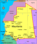
Mauritania
Facts & Figures
-
President: Muhammad Ould Abdel Aziz (2009)
Prime Minister: Yahya Ould Hademine (2014)
Land area: 397,837 sq mi (1,030,400 sq km); total area: 397, 953 sq mi (1,030,700 sq km)
Population (2014 est.): 3,516,806 (growth rate: 2.26%); birth rate: 31.83/1000; infant mortality rate: 56.06/1000; life expectancy: 62.28
Capital and largest city (2011 est.): Nouakchott, 786,000
Monetary unit: Ouguiya
National name: Al Jumhuriyah al Islamiyah al Muritaniyah
Languages: Arabic (official and national), Pulaar, Soninke, Wolof (all national languages), French, Hassaniya (a variety of Arabic)
Ethnicity/race: black Moors (Haratines - Arab-speaking slaves, former slaves, and their descendants of African origin, enslaved by white Moors) 40%, white Moors (of Arab-Berber descent, known as Bidhan) 30%, black Africans (non-Arabic speaking, Halpulaar, Soninke, Wolof, and Bamara ethnic groups) 30%
Religion: Islam 100%
National Holiday: Independence Day, Nov. 28
Literacy rate: 58.6% (2011 est.)
Economic summary: GDP/PPP (2013 est.): $8.2046 billion; per capita $2,200. Real growth rate: 6.4%. Inflation: 4.6%. Unemployment: 30% (2008 est.). Arable land: 0.44%. Agriculture: dates, millet, sorghum, rice, corn; cattle, sheep. Labor force: 1.318 million (2007); agriculture 50%, services 48%, industry 2% (2001 est.). Industries: fish processing, mining of iron ore and gypsum. Natural resources: iron ore, gypsum, copper, phosphate, diamonds, gold, oil, fish. Exports: $2.728 billion (2013 est.): iron ore, fish and fish products, gold. Imports: $3.335 billion (2013 est.): machinery and equipment, petroleum products, capital goods, foodstuffs, consumer goods. Major trading partners: Japan, France, Germany, Spain, Italy, Belgium, Côte d'Ivoire, China, U.S., Brazil (2012).
Communications: Telephones: main lines in use: 65,100 (2012); mobile cellular: 4.024 (2012). Broadcast media: one state-run TV (Television de Mauritanie) and one state-run radio network (Radio de Mauritanie); Television de Mauritanie has three channels, Al Mahadra station (for Islamic content) and Channels 1 and 2, which cover news, sports, and other programming; Radio de Mauritanie runs 12 regional stations as well as a radio station for youth and the Holy Quran station; five private TV channels and five private radio stations also broadcast from Mauritania; six private international radio stations broadcast in Mauritania on the FM band; with satellite connections, Mauritanians also have access to hundreds of foreign TV channels (2013). Internet Service Providers (ISPs): 22 (2012). Internet users: 75,000 (2009).
Transportation: Railways: total: 728 km (2008). Highways: total: 10,628 km; paved: 3,158 km; unpaved: 7,470 km (2010). Waterways: some navigation possible on the Senegal River. Ports and terminals: Nouadhibou, Nouakchott. Airports: 30 (2013).
International disputes: Mauritanian claims to Western Sahara have been dormant in recent years.
