Nauru
Facts & Figures

-
President: Russ Kun (2022)
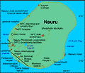
Total area: 8 sq mi (21 sq km)
Population (2022 est.): 9,811 (growth rate: 0.42%); birth rate: 21.1/1000; infant mortality rate: 7.84/1000; life expectancy: 67.93
Capital: no official capital; government offices in Yaren District
Monetary unit: Australian dollar
Languages: Nauruan 93% (official, a distinct Pacific Island language), English 2% (widely understood, spoken, and used for most government and commercial purposes), other 5% (includes I-Kiribati 2% and Chinese 2%) note: percentages represent main language spoken at home; Nauruan is spoken by 95% of the population, English by 66%, and other languages by 12% (2011 est.)
Ethnicity/race: Nauruan 88.9%, part Nauruan 6.6%, I-Kiribati 2%, other 2.5% (2007 est.)
Religions: Protestant 60.4% (includes Nauru Congregational 35.7%, Assembly of God 13%, Nauru Independent Church 9.5%, Baptist 1.5%, and Seventh Day Adventist .7%), Roman Catholic 33%, other 3.7%, none 1.8%, unspecified 1.1% (2011 est.)
National Holiday: Independence Day, January 31
Literacy rate: n.a
Economic summary: GDP/PPP (2019 est.): $150 million; per capita $13,5000. Real growth rate: 4% Inflation: 5.1%. Unemployment: 23% (2011 est.). Arable land: 0%. Agriculture: coconuts. Labor force: mining phosphates, public administration, education, and transportation. Industries: phosphate mining, offshore banking, coconut products. Natural resources: phosphates. Exports: $30 million (2018): phosphates. Major trading partners (exports): Thailand 34%, Australia 16%, United States 13%, South Korea 10%, Philippines 9%, Japan 7%, France 5% (2019). Imports: 90 million (2019 est.): food, fuel, manufactures, building materials, machinery. Major trading partners (imports): Taiwan 52%, Australia 28% (2019).
Special relationship within the Commonwealth of Nations
Communications: Telephones: main lines in use: 1,900 (2009); mobile cellular: 10,000 (2020). Broadcast media: 1 government-owned TV station broadcasting programs from New Zealand sent via satellite or on videotape; 1 government-owned radio station, broadcasting on AM and FM, utilizes Australian and British programs (2019). Internet hosts: 8,162 (2012). Internet users: 6,136 (2019),
Transportation: Railways: total: 5 km; note: used to haul phosphates from the center of the island to processing facilities on the southwest coast (2001). Roadways: total: 30 km; paved: 24 km (2002). Ports and harbors: Nauru. Airports: 1 (2021).
International disputes: none.

