Zambia
Facts & Figures
-
President: Edgar Lungu (2015)
Land area: 285,994 sq mi (740,724 sq km); total area: 290,586 sq mi (sq km)
Population (2014 est.): 14,638,505 (growth rate: 2.88%); birth rate: 2.88/1000; infant mortality rate: 66.62/1000; life expectancy: 51.83.
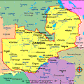
Capital and largest city (2011 est.): Lusaka (capital) 1.802 million
Monetary unit: Kwacha
Republic of Zambia
Languages: Bembe 33.4%, Nyanja 14.7%, Tonga 11.4%, Chewa 4.5%, Lozi 5.5%, Nsenga 2.9%, Tumbuka 2.5%, Lunda (North Western) 1.9%, Kaonde 1.8%, Lala 1.8%, Lamba 1.8%, English (official) 1.7%, Luvale 1.5%, Mambwe 1.3%, Namwanga 1.2%, Lenje 1.1%, Bisa 1%, other 9.4%, unspecified 0.4% (2010 est.)
Ethnicity/race: Bemba 21%, Tonga 13.6%, Chewa 7.4%, Lozi 5.7%, Nsenga 5.3%, Tumbuka 4.4%, Ngoni 4%, Lala 3.1%, Kaonde 2.9%, Namwanga 2.8%, Lunda (north Western) 2.6%, Mambwe 2.5%, Luvale 2.2%, Lamba 2.1%, Ushi 1.9%, Lenje 1.6%, Bisa 1.6%, Mbunda 1.2%, other 13.8%, unspecified 0.4% (2010 est.)
Religions: Protestant 75.3%, Roman Catholic 20.2%, other 2.7% (includes Muslim Buddhist, Hindu, and Baha'i), none 1.8% (2010 est.)
Literacy rate: 61.4% (2007 est.)
Economic summary: GDP/PPP (2013 est.): $25.47 billion; per capita $1,800. Real growth rate: 6%. Inflation: 7.1%. Unemployment: 15% (2008 est.). Arable land: 4.52%. Agriculture: corn, sorghum, rice, peanuts, sunflower seeds, vegetables, flowers, tobacco, cotton, sugarcane, cassava (manioc, tapioca), coffee; cattle, goats, pigs, poultry, milk, eggs, hides. Labor force: 6.275 million (2013); agriculture 85%, industry 6%, services 9% (2004). Industries: copper mining and processing, emerald mining, construction, foodstuffs, beverages, chemicals, textiles, fertilizer, horticulture. Natural resources: copper, cobalt, zinc, lead, coal, emeralds, gold, silver, uranium, hydropower. Exports: $8.547 billion (2013 est.): copper/cobalt, cobalt, electricity, tobacco, flowers, cotton. Imports: $8.216 billion (2013 est.): machinery, transportation equipment, petroleum products, electricity, fertilizer; foodstuffs, clothing. Major trading partners: South Africa, China, Democratic Republic of the Congo, Kuwait, South Korea, India, UAE, Egypt (2012).
Communications: Telephones: main lines in use: 82,500 (2012); mobile cellular: 10.525 million (2012). Broadcast media: State-owned Zambia National Broadcasting Corporation (ZNBC) operates 1 TV station and is the principal local-content provider; several private TV stations are available; multi-channel subscription TV services are obtainable; ZNBC operates 3 radio networks; about 2 dozen private radio stations also broadcasting; relays of at least 2 international broadcasters are accessible in Lusaka and Kitwe (2007). Internet Service Providers (ISPs): 16,571 (2012). Internet users: 816,200 (2009).
Transportation: Railways: total: 2,922 km (2013). Highways: total: 67,671 km; paved: 9,403 km ; unpaved: 31,051 km (2013 est.). Waterways: 2,250 km, including Zambezi and Luapula rivers, Lake Tanganyika. Ports and harbors: Mpulungu. Airports: 88 (2013).
International conflicts: In 2004, Zimbabwe dropped objections to plans between Botswana and Zambia to build a bridge over the Zambezi River, thereby de facto recognizing a short, but not clearly delimited, Botswana-Zambia boundary in the river.
