World Time Zones and Time Zone Map

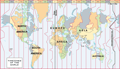 |
Time zones did not become necessary in the United States until trains made it possible to travel hundreds of miles in a day. Until the 1860s most cities relied upon their own local “sun” time, but this time changed by approximately one minute for every 12 miles traveled east or west. The problem of keeping track of over 300 local times was overcome by establishing railroad time zones. Until 1883 most railway companies relied on some 100 different, but consistent, time zones.
That year, the United States was divided into four time zones roughly centered on the 75th, 90th, 105th, and 120th meridians. At noon, on November 18, 1883, telegraph lines transmitted GMT time to major cities where authorities adjusted their clocks to their zone's proper time.
On November 1, 1884, the International Meridian Conference in Washington, D. C., applied the same procedure to zones all around the world. The 24 standard meridians, every 15 east and west of 0 at Greenwich, England, were designated the centers of the zones. The international dateline was drawn to generally follow the 180 meridian in the Pacific Ocean. Because some countries, islands and states do not want to be divided into several zones, the zones' boundaries tend to wander considerably from straight north-south lines.
Trending
Here are the facts and trivia that people are buzzing about.


