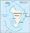
Mayotte
Facts & Figures

- Status: Territorial CollectivityPrefect: Jacques Witkowski (2013)Total area: 145 sq mi (376 sq km)Population (2009 est.): 194,000 (growth rate: 3.4%); birth rate: 39.7/1000; infant mortality rate: 57.8/1000; life expectancy: 62.5; density per sq mi: 1,291.2Capital (2007 est.): Mamoudzou, 53,022Languages: Mahorian (a Swahili dialect), French (official language) spoken by 35% of the populationReligions: Islam 97%, Christian (mostly Roman Catholic).Economic summary: GDP/PPP (2005 est.): $1.13 billion; per capita $6,500. Real growth rate: n.a. Inflation: n.a. Unemployment: 38% (1999). Arable land: n.a. Agriculture: vanilla, ylang-ylang (perfume essence), coffee, copra. Labor force: 48,800 (2000). Industries: newly created lobster and shrimp industry, construction. Natural resources: negl. Exports: $3.44 million (f.o.b., 1997): ylang-ylang (perfume essence), vanilla, copra, coconuts, coffee, cinnamon. Imports: $141.3 million (f.o.b., 1997): food, machinery and equipment, transportation equipment, metals, chemicals. Major trading partners: France, Comoros, Réunion, Africa, Southeast Asia (2004).Communications: Telephones: main lines in use: 10,000 (2001); mobile cellular: 21,700 (2002). Radio broadcast stations: AM 1, FM 5, shortwave 0 (2001). Television broadcast stations: 3 (2001). Internet hosts: n.a. Internet users: n.a.Transportation: Railways: 0 km. Highways: total: 93 km; paved: 72 km; unpaved: 21 km. Ports and harbors: Dzaoudzi. Airports: 1 (2004 est.).International disputes: claimed by Comoros.Major sources and definitions
Index
See also:
