Dependencies of Norway

Read about the geography, population, and characteristics of Norway's dependencies, which include Svalbard, Bouvet Island, and Jan Mayen Island.
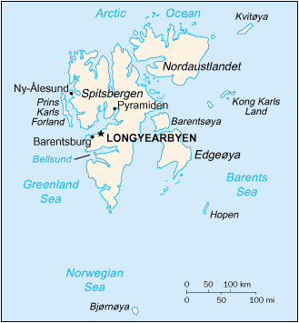 Map of Svalbard Source: The World Factbook 2003 |
Svalbard (23,957 sq mi; 62,049 sq km), in the Arctic Ocean about 360 mi north of Norway, consists of the Spitsbergen group and several smaller islands, including Bear Island, Hope Island, King Charles Land, and White Island (or Gillis Land). The capital is Longyearbyen. It came under Norwegian administration in 1925. Population: 2,701 (2005 est.). 62% of the population is Russian and Ukrainian; 38% is Norwegian. Coal mining is the major economic activity.
 Map of Bouvet Source: The World Factbook 2003 |
Bouvet Island (23 sq mi; 58.5 sq km), an island nature reserve in the South Atlantic about 1,600 mi south-southwest of the Cape of Good Hope, came under Norwegian administration in 1928. It is uninhabited.
See also Bouvet Island: The Most Remote Spot on Earth.
 Map of Jan Mayen Island Source: The World Factbook 2003 |
Jan Mayen Island (144 sq mi; 373 sq km), in the Arctic Ocean between Norway and Greenland, came under Norwegian administration in 1929. There are no permanent inhabitants, just workers at the navigation base and weather/radio station.