Weather: Doppler—the New Generation
Doppler—the New Generation
Although the original radar systems provided useful information, its displays were often confusing and never went far enough in detecting severe weather. The last version of the conventional radar was produced in 1957. By the late 1980s, spare parts for this antique were becoming harder to find—mainly available in the former Soviet Union. It was time for some new technology. In 1988 a new version was put into official operation, part of a National Weather Service multimillion-dollar modernization effort known as NEXRAD, Next Generation Weather Radar, or the WSR-88 (Weather Surveillance Radar-1988). These are Doppler radar systems.
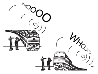
The Doppler effect.
The Doppler effect was first applied to the apparent shifting frequencies of, say, a train whistle as it approaches and then passes. When the sound is approaching, the waves are pushed together more than when the source moves away. That makes sense (see the following figure). When the waves are pushed together, the wavelength is shorter, and the frequency is higher. As a train approaches, the higher frequency of its whistle is heard as a higher pitch. Then, where the waves are stretched, the wavelength is longer, and the frequency is less. So as a train departs, its whistle will sound at a lower pitch. That's the Doppler shift.
The Doppler shift works with light waves as well as sound waves. For example, astronomers have concluded that the universe is expanding because of the shift to longer wavelengths, or red shift, by distant galaxies. That shift indicates that these galaxies are moving away from the earth.
Weather-Speak
NEXRAD stands for Next Generation Weather Radar and is the National Weather Service's new Doppler radar network installed in the 1990s. Doppler radar detects precipitation and measures the speed of falling precipitation, like conventional radar. But Doppler also measures the speed at which precipitation is moving horizontally toward or away from the radar.
When microwaves are used, the Doppler shift will indicate whether raindrops are moving away from the radar or toward it. That motion is called radial velocity. Doppler radars not only detect precipitation, they also tell us something about how the air is behaving. Also the Doppler radar is more sensitive than the old 1957 conventional version, and its reflectivity is more exacting.
Weather-Speak
The change in frequency of sound waves when an object is moving toward or away from you is called the Doppler shift, or Doppler effect.
Many levels of precipitation can be detected. In severe weather, winds tend to shift dramatically. For example, in one location, the flow will appear to be away from the radar, and adjacent to that will be a flow that is directed away. These outgoing or incoming motions are color-coded on the Doppler radar so when a sharp change in direction takes place, the colors contrast sharply. That contrast indicates that a severe storm is present, even a tornado. That wind difference is called wind shear. You can demonstrate this easily by putting a pen between your two hands. Move your left hand in one direction and your right hand in the other. What happens to the pen? It will rotate. That rotation can be detected on the radar screen by looking at the color shift of the radial velocity. A strong shift is a tip-off that some severe weather is happening.
Weather-Speak
Wind shear is the rate of change of wind direction or speed, especially when it is a sudden variation. It can be dangerous to aircraft when landing or taking off.
In violent thunderstorms, the individual storm cells are part of a larger rotating cloud mass. That is called a mesocyclone. This rotation shows up nicely on the Doppler radar screen, thanks to the shifting frequencies. Approximately half of all mesocyclones are associated with tornadoes. And when tornadoes do appear, strong wind shears show up within the mesocyclone itself. There's a special tornado signature that appears as those shifting colors, called a tornado vortex signature (TVS). The tornado-detection capability of Doppler works best within 50 miles of the antenna.
Weather-Speak
A mesocyclone is the intense rotating region of air containing a severe thunderstorm. Tornado vortex signature (TVS) is the image of tornadic wind shear found on a Doppler radar screen. It shows up inside a mesocyclone.
In the old conventional radar days, tornado warnings were only issued when a tornado was spotted on the ground. Today tornado and severe thunderstorm warnings are given as soon as the signatures appear on the screen. The warning can be issued as much as 20 minutes before a tornado touchdown. That isn't huge, but it's far better than a warning after the fact, which was common in former times. Now the alarm can go off and provide enough time to seek shelter. It's important to realize that Doppler doesn't show the actual velocity of the air—only the velocity away or toward the radar. If the motion is perpendicular to the outgoing beams, that motion won't be detected. A double-Doppler system would be helpful here, but even a single Doppler can provide a wealth of useful data.
During the 1990s, more than 150 NEXRAD sites were established across the United States and its island territories. The National Weather Service, Department of Defense, and the Federal Aviation Administration participated in the effort. In addition to providing detailed reflectivity, NEXRAD provides rainfall accumulations for one and three hours, as well as storm totals. Specially designed algorithms allow for these displays as well as hourly rainfall rates and vertically integrated liquid water, which is the total amount of water from the ground up to the top of the atmosphere. That's a lot of information.
Excerpted from The Complete Idiot's Guide to Weather © 2002 by Mel Goldstein, Ph.D.. All rights reserved including the right of reproduction in whole or in part in any form. Used by arrangement with Alpha Books, a member of Penguin Group (USA) Inc.