Congo, Republic of
Facts & Figures
-
President: Denis Sassou-Nguesso (1997)
Prime Minister: Denis Sassou-Nguesso
Land area: 131,853 sq mi (341,499 sq km); total area: 132,047 sq mi (342,000 sq km)
Population (2014 est.): 4,662,446 (growth rate: 1.94%); birth rate: 36.59/1000; infant mortality rate: 59.34/1000; life expectancy: 58.52
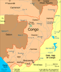
Capital and largest city (2011 est.): Brazzaville, 1.611
Other large city: Pointe-Noire, 834,000
Monetary unit: CFA Franc
National name: République du Congo
Languages: French (official), Lingala, Monokutuba, Kikongo, many local languages and dialects
Ethnicity/race: Kongo 48%, Sangha 20%, M'Bochi 12%, Teke 17%, Europeans and other 3%
National Holiday: Independence Day, August 15
Religions: Roman Catholic 33.1%, Awakening Churches/Christian Revival 22.3%, Protestant 19.9%, Salutiste 2.2%, Muslim 1.6%, Kimbanguiste 1.5%, other 8.1%, none 11.3% (2010 est.)
Literacy rate: 83.8% (2003 est.)
Economic summary: GDP/PPP (2013 est.): $20.26 billion; per capita $4,800. Real growth rate: 5.8%. Inflation: 1.7%. Unemployment: 53% (2012). Arable land: 1.46%. Agriculture: cassava (tapioca), sugar, rice, corn, peanuts, vegetables, coffee, cocoa; forest products. Labor force: 2.89 million (2011) Industries: petroleum extraction, cement, lumber, brewing, sugar, palm oil, soap, flour, cigarettes. Natural resources: petroleum, timber, potash, lead, zinc, uranium, copper, phosphates, natural gas, hydropower. Exports: $9.912 billion (2013 est.): petroleum, lumber, plywood, sugar, cocoa, coffee, diamonds. Imports: $4.297 billion (2013 est.): capital equipment, construction materials, foodstuffs. Major trading partners: China, U.S., France, Belgium, India, Australia, Spain, Italy, Netherlands (2004).
Communications: Telephones: main lines in use: 14,900 (2012); mobile cellular: 4.283 million (2012). Broadcast media: 1 state-owned TV and 3 state-owned radio stations; several privately owned TV and radio stations; satellite TV service is available; rebroadcasts of several international broadcasters are available (2007). Internet hosts: 45 (2012). Internet users: 245,200 (2009).
Transportation: Railways: total: 886 km (2008). Highways: total: 17,289 km; (2004 est.). Waterways: 1,120 km (commercially navigable on Congo and Oubanqui rivers above Brazzaville; there are many ferries across the river to Kinshasa; the Congo south of Brazzaville-Kinshasa to the coast is not navigable because of rapids, thereby necessitating a rail connection to Pointe Noire; other rivers are used for local traffic only) (2011). Ports and harbors: Brazzaville, Djeno, Impfondo, Ouesso, Oyo, Pointe-Noire. Airports: 27 (2013 est.).
International disputes: the location of the boundary in the broad Congo River with the Democratic Republic of the Congo is undefined except in the Pool Malebo/Stanley Pool area.