Weather: Telling What's Next
Telling What's Next
Much of the art of weather forecasting focuses on understanding the distribution of weather around these frontal cyclones and knowing when conditions will be just right for their formation.
Weather watchers study upper-air charts for clues about where divergence might be occurring. If those outflow areas occur over a stationary front, there's a good chance that one of those innocent waves will become unstable and turn into a full-fledged low-pressure area. It turns out that those same upper-wind patterns provide a clue about which path these storms will follow. That upper-wind current, known as the jet stream, reflects the general direction in which the weather flows. Often a frontal cyclone will move along the path of those winds at 18,000 feet and at a speed that is approximately half of the upper-level flow. A good cross-section of the atmosphere not only shows us whether a storm will form, but where it might be going.
Snow for Christmas?
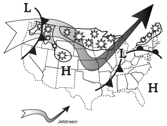
The figure shows a typical weather map for a fictitious December 24. The question on any December 24 is whether anyone will experience a white Christmas. If the jetstream is pushing the center of low pressure toward the northeast, places like Chicago, Cleveland, and Buffalo will get snow in a big way. These locations will stay in the cold sector of the storm.
The speed and intensity of the storm will help determine how much snow will accumulate. But sorry, snow lovers in Washington, New York, and Boston—the warmer sector of the storm will be pushing through, which means rain rather than snow on Christmas morning. But there's always New Year's Eve.
This basic forecast technique was used routinely prior to the computer age; these days the forecast is automated. We'll have more on the new age of forecasting later. But there's really no substitute for looking out the window or at a weather map. It works!
Braving the Elements
A classic but severe frontal cyclone was the famous Blizzard of 1888. It hit the northeastern United States on March 12, 1888. The snowfall totaled 40 to 50 inches with drifts as high as 30 to 40 feet. There were 400 deaths resulting from this great blizzard.
Weather-Speak
A jet stream is made up of relatively strong horizontal ribbons of wind found at the earth's tropopause, which is 6 to 10 miles above the ground.
Excerpted from The Complete Idiot's Guide to Weather © 2002 by Mel Goldstein, Ph.D.. All rights reserved including the right of reproduction in whole or in part in any form. Used by arrangement with Alpha Books, a member of Penguin Group (USA) Inc.