Hungary
Facts & Figures
-
President: Janos Ader (2012)
Prime Minister: Viktor Orban (2010)
Land area: 35,653 sq mi (92,341 sq km); total area: 35,919 sq mi (93,030 sq km)
Population (2014 est.): 9,919,128 (growth rate: –0.21%); birth rate: 9.26/1000; infant mortality rate: 5.09/1000; life expectancy: 75.46
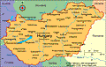
Capital and largest city (2011 est.): Budapest, 1.737 million
Monetary unit: Forint
National name: Magyar Köztársaság
Languages: Magyar (Hungarian) 84.6%, other 16.4%
Ethnicity/race: Hungarian 92.3%, Roma 1.9%, other or unknown 5.8% (2001)
Religions: Roman Catholic 37.2%, Calvinist 11.6%, Lutheran 2.2%, Greek Catholic 1.8%, other 1.9%, none 18.2%, unspecified 27.2% (2011 est.)
National Holiday: Saint Stephen's Day, August 20
Literacy rate: 99% (2011 est.)
Economic summary: GDP/PPP (2013 est.): $196.6 billion; per capita $19,800 Real growth rate: 0.2%. Inflation: 1.9%. Unemployment: 10.5%. Arable land: 47.24%. Agriculture: wheat, corn, sunflower seed, potatoes, sugar beets; pigs, cattle, poultry, dairy products. Labor force: 4.263 million; agriculture 7.1%, industry 29.7%, services 63.2% (2010). Industries: mining, metallurgy, construction materials, processed foods, textiles, chemicals (especially pharmaceuticals), motor vehicles. Natural resources: bauxite, coal, natural gas, fertile soils, arable land. Exports: $92.98 billion (2013 est.): machinery and equipment 53.5%, other manufactures 31.2%, food products 8.7%, raw materials 3.4%, fuels and electricity 3.9% (2012). Imports: $89.52 billion (2013 est.): machinery and equipment 45.4%, other manufactures 34.3%, fuels and electricity 12.6%, food products 5.3%, raw materials 2.5% (2012). Major trading partners: Germany, Austria, France, Italy, UK, Romania, Poland, Russia, Netherlands, China, Slovakia (2012).
Communications: Telephones: main lines in use: 2.96 million (2012); mobile cellular: 11.58 million (2012). Broadcast media: mixed system of state-supported public service broadcast media and private broadcasters; the 3 publicly-owned TV channels and the 2 main privately-owned TV stations are the major national broadcasters; a large number of special interest channels; highly developed market for satellite and cable TV services with about two-thirds of viewers utilizing their services; 3 state-supported public-service radio networks and 2 major national commercial stations; a large number of local stations including commercial, public service, nonprofit, and community radio stations; digital transition postponed to the end of 2014 (2007). Internet hosts: 3.145 million (2012). Internet users: 6.176 million (2009).
Transportation: Railways: total: 8,057 km (2009). Roadways: total: 199,567 km; paved: 76,075 km (including 911 km of expressways); unpaved: 123,492 km (2010). Waterways: 1,622 km (most on Danube River) (2011). Ports and harbors: Budapest, Dunaujvaros, Gyor-Gonyu, Csepel, Baja, Mohacs. Airports: 41 (2013).
International disputes: bilateral government, legal, technical and economic working group negotiations continue in 2006 with Slovakia over Hungary's failure to complete its portion of the Gabcikovo-Nagymaros hydroelectric dam project along the Danube; as a member state that forms part of the EU's external border, Hungary has implemented the strict Schengen border rules.
Index
- Hungary Profile
- History
- News and Current Events
Geography
This central European country is the size of Indiana. Most of Hungary is a fertile, rolling plain lying east of the Danube River and drained by the Danube and Tisza rivers. In the extreme northwest is the Little Hungarian Plain. South of that area is Lake Balaton (250 sq mi; 648 sq km).
Government
Parliamentary democracy.
History
By 14 B.C., western Hungary was part of the Roman Empire's provinces of Pannonia and Dacia. The area east of the Danube was never part of the Roman Empire and was largely occupied by various Germanic and Asiatic peoples. In 896 all of Hungary was invaded by the Magyars, who founded a kingdom. Christianity was accepted during the reign of Stephen I (St. Stephen), 977–1038. A devastating invasion by the Mongols killed half of Hungary's population in 1241. The peak of Hungary's great period of medieval power came during the reign of Louis I the Great (1342–1382), whose dominions touched the Baltic, Black, and Mediterranean seas. War with the Turks broke out in 1389, and for more than 100 years the Turks advanced through the Balkans. When the Turks smashed a Hungarian army in 1526, western and northern Hungary accepted Hapsburg rule to escape Turkish occupation. Transylvania became independent under Hungarian princes. Intermittent war with the Turks was waged until a peace treaty was signed in 1699.
Wars Cost Hungary Much of Its Land
After the suppression of the 1848 revolt, led by Louis Kossuth, against Hapsburg rule, the dual monarchy of Austria-Hungary was set up in 1867. The dual monarchy was defeated, along with the other Central Powers, in World War I. After a short-lived republic in 1918, the chaotic Communist rule of 1919 under Béla Kun ended with the Romanians occupying Budapest on Aug. 4, 1919. When the Romanians left, Adm. Nicholas Horthy entered the capital with a national army. The Treaty of Trianon of June 4, 1920, by which the Allies parceled out Hungarian territories, cost Hungary 68% of its land and 58% of its population.
In World War II, Hungary allied with Germany, which aided the country in recovering lost territories. Following the German invasion of Russia on June 22, 1941, Hungary joined the attack against the Soviet Union, but withdrew in defeat from the eastern front by May 1943. Germany occupied the country for the remainder of the war and set up a puppet government. Hungarian Jews and Gypsies were sent to death camps. The German regime was driven out by the Soviets in 1944–1945.
Communist Party Takes Control
By the Treaty of Paris (1947), Hungary had to give up all territory it had acquired since 1937 and to pay $300 million in reparations to the USSR, Czechoslovakia, and Yugoslavia. In 1948, the Communist Party, with the support of Soviet troops, seized control. Hungary was proclaimed a People's Republic and one-party state in 1949. Industry was nationalized, the land collectivized into state farms, and the opposition terrorized by the secret police. The terror, modeled after that of the USSR, reached its height with the trial and life imprisonment of József Cardinal Mindszenty, the leader of Hungary's Roman Catholics, in 1948.
On Oct. 23, 1956, an anti-Communist revolution broke out in Budapest. To cope with it, the Communists set up a coalition government and called former prime minister Imre Nagy back to head the government. But he and most of his ministers sympathized with the anti-Communist opposition, and he declared Hungary a neutral power, withdrawing from the Warsaw Treaty and appealing to the United Nations for help. One of his ministers, János Kádár, established a counterregime and asked the USSR to send in military power. Soviet troops and tanks suppressed the revolution in bloody fighting after 190,000 people had fled the country. Under Kádár (1956–1988), Communist Hungary maintained more liberal policies in the economic and cultural spheres, and Hungary became the most liberal of the Soviet-bloc nations of eastern Europe. Continuing his program of national reconciliation, Kádár emptied prisons, reformed the secret police, and eased travel restrictions.
Hungary Makes Difficult Transition to Democracy
In 1989, Hungary's Communists abandoned their monopoly on power voluntarily, and the constitution was amended in Oct. 1989 to allow for a multiparty state. The last Soviet troops left Hungary in June 1991, thereby ending almost 47 years of military presence. The transition to a market economy proved difficult. In April 1999, Hungary became part of NATO, and in May 2004, it joined the EU. In 2006, Prime Minister Ferenc Gyurcsány was reelected on a platform promising economic “reform without austerity.” In September, a tape was leaked to the media on which Prime Minister Gyurcsany admited that he blatantly lied about the state of the economy to win reelection. Antigovernment demonstrators rioted and demanded his resignation.
In November 2008, the IMF extended a $25 billion rescue package to Hungary to help its battered currency and stockmarket during the global financial crisis.
Amidst the economic turmoil, economy minister, Gordon Bajnai, agreed to succeed Ferenc Gyurcsany as prime minister in April 2009. Gyurcsany resigned after failing to help Hungary's economy during the global economic crisis.
The Fidesz Party Forms a New Government
In a decisive victory, Viktor Orban and his center-right political party, Fidesz, won a two-thirds majority in parliamentary elections in April 2010, taking 263 of 386 seats. The ruling party, the Socialists, won just 59 seats, and the far-right Jobbik party and a new liberal-green group, LMP (Politics Can be Different), took the remaining 63. The Jobbik party, with its black-clad paramilitary and anti-Semitic extremism, has worried Hungarians and international leaders alike, particularly now that it has entered parliament for the first time. Economic hardship in Hungary has fueled the nationalistic party, but the newly strong majority of the Fidesz party means that it won't have to negotiate with the Jobbiks, thus weakening their power.
Orban was appointed prime minister. He introduced several laws that increased government control over the media, judiciary, and central bank. In April 2011, parliament approved a new "majoritarian" constitution, which went into effect in January 2012 to widespread disapproval and fear that the document consolidated the power of Fidesz at the expense of democracy. In a rare display of unity, opposition groups joined together in early January and organized protests against the new constitution. About 30,000 people participated.
European Union Warns Hungary
In early January 2012, the European Union (EU) gave Hungary an ultimatum. The European Commission, the executive branch of the EU, warned that it would take legal action by January 17 unless the country modified the new laws it passed at the end of 2011. The laws, along with a new constitution, removed regulations on Prime Minister Viktor Orban's government in areas such as the media, central banking, and the judiciary. Orban relented, and in a speech to parliament said, the issue "could swiftly be resolved and remedied." In a separate warning, the European Commission said Hungary faced a possible loss of development assistance if the country did not do more to rein in its budget deficit. That was followed in March with the European Union telling Hungary it would suspend about 500 million euros in development aid unless the country show progress in cutting its deficit to 2.5% of GDP by June.
President Schmitt resigned in April 2012 after Budapest's Semmelweis University withdrew his doctorate degree. A university committee issued a report that accused Schmitt of plagiarizing in his 1992 thesis. In May, the parliament elected Janos Ader, 52, Hungarian president.
New Amendment to the Constitution Causes Alarm
In March 2013, Hungary's Parliament passed a lengthy amendment to its Constitution. The 386-seat Parliament passed the controversial amendment by a vote of 265 to 11. The amendment was considered controversial because it included several laws seen as a way for the government to regulate media, education, and even the social life of its citizens. For example, one law allowed local police to fine or jail homeless people. Another law required that state scholarship students either stay in Hungary or pay back their scholarships if they leave.
Thousands protested the amendment in Budapest. It also raised concern throughout the international community, including the Council of Europe, European Union, human rights activists, and the United States. A joint statement was released by Thorbjorn Jagland, head of the Council of Europe, and European Commission President José Manuel Barroso. The statement said that the amendment increased "concerns with respect to the principle of the rule of law, European Union law and Council of Europe standards."
In April 2014's parliamentary elections, the ruling Fidesz party won another victory, taking 133 of the 199 available seats. The win handed Orban a third term as prime minister. The election was the first to follow the country's new constitution and electoral rules since Hungary's transition to democracy. In October 2014, the government announced plans to impose a tax on Internet use. Tens of thousands of people took to the streets of Budapest to protest the proposal. In response, Orban said he would put a cap on the tax. It was not enough to quiet the protests, and Orban withdrew the plan just over a week after introducing it.
In Feb. 2015, Hungary's ruling right-wing alliance, led by Prime Minister Orban and his Fidesz party, lost its majority in parliament in a by-election. The results showed an increase in support for the far-right Jobbik party and a fall in the support for Fidesz, only a year after Fidesz swept national elections in an alliance with the KDNP party. The loss of a majority hurt Orban's chances to pass any major legislation or change the constitution. Of the election results, Orban said via social media that Fidesz "cannot sit on its laurels." The next election was planned for 2018.
Hundreds of Migrants Held in Hungary During Crisis of 2015

AP Photo/Petr David Josek Migrants desperately seeking passage to Germany at a train station in Bicske, Hungary
During the summer of 2015, migrants fleeing war and conflict in Afghanistan, Syria, and regions of Northern Africa poured into the Balkans at a rate of about 3,000 a day. They hoped to end up in Western Europe, but many of those nations only offered refuge to a small number of migrants. The impasse created a crisis in Hungary, where thousands of migrants were stuck at Budapest's Keleti train station in August and early September as they waited for officials to decide their fate. Hungary responded to the influx by building 109-foot razor-wire fence along the Serbian border and passing laws allowing the arrest of migrants who attempt to cross into Hungary from Serbia illegally.
See also Encyclopedia: Hungary .
U.S. State Dept. Country Notes: Hungary