Geography
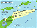
East Timor is located in the eastern part of Timor, an island in the Indonesian archipelago that lies between the South China Sea and the Indian Ocean. East Timor includes the enclave of Oecussi, which is located within West Timor (Indonesia). After Indonesia, East Timor's closest neighbor is Australia, 400 mi to the south. It is semiarid and mountainous.
Government
Republic.
History
Timor was first colonized by the Portuguese in 1520. The Dutch, who claimed many of the surrounding islands, took control of the western portion of the island in 1613. Portugal and the Netherlands fought over the island until an 1860 treaty divided Timor, granting Portugal the eastern half of the island as well as the western enclave of Oecussi (the first Portuguese settlement on the island). Australia and Japan fought each other on the island during World War II; nearly 50,000 East Timorese died during the subsequent Japanese occupation.
In 1949, the Netherlands gave up its colonies in the Dutch East Indies, including West Timor, and the nation of Indonesia was born. East Timor remained under Portuguese control until 1975, when the Portuguese abruptly pulled out after 455 years of colonization. The sudden Portuguese withdrawal left the island vulnerable. On July 16, 1976, nine days after the Democratic Republic of East Timor was declared an independent nation, Indonesia invaded and annexed it. Although no country except Australia officially recognized the annexation, Indonesia's invasion was sanctioned by the United States and other western countries, who had cultivated Indonesia as a trading partner and cold-war ally (Fretilin, the East Timorese political party spearheading independence, was Marxist at the time).
Indonesia's Human Rights Abuses Focus International Attention on East Timor's Bid for Independence
Indonesia's invasion and its brutal occupation of East Timor—small, remote, and desperately poor—largely escaped international attention. East Timor's resistance movement was violently suppressed by Indonesian military forces, and more than 200,000 Timorese were reported to have died from famine, disease, and fighting since the annexation. Indonesia's human rights abuses finally began receiving international notice in the 1990s, and in 1996 two East Timorese activists, Bishop Carlos Filipe Ximenes Belo and José Ramos-Horta, received the Nobel Peace Prize for their efforts to gain freedom peacefully.
After Indonesia's hard-line president Suharto left office in 1998, his successor, B. J. Habibie, unexpectedly announced his willingness to hold a referendum on East Timorese independence, reversing 25 years of Indonesian intransigence. As the referendum on self-rule drew closer, fighting between separatist guerrillas and pro-Indonesian paramilitary forces in East Timor intensified. The UN-sponsored referendum had to be rescheduled twice because of violence. On Aug. 30, 1999, 78.5% of the population voted to secede from Indonesia. But in the days following the referendum, pro-Indonesian militias and Indonesian soldiers retaliated by razing towns, slaughtering civilians, and forcing a third of the population out of the province. After enormous international pressure, Indonesia finally agreed to allow UN forces into East Timor on Sept. 12. Led by Australia, an international peacekeeping force began restoring order to the ravaged region.
East Timor Declares Independence
The UN Transitional Authority in East Timor (UNTAET) then governed the territory for nearly three years. On May 20, 2002, nationhood was declared. Charismatic rebel leader José Alexandre Gusmão, who was imprisoned in Indonesia from 1992 to 1999, was overwhelmingly elected the nation's first president on April 14, 2002. The president has a largely symbolic role; real power rests with Parliament and Prime Minister Mari Alkatiri, also a former guerrilla leader.
The first new country of the millennium, East Timor is also one of the world's poorest. Its meager infrastructure was destroyed by the Indonesian militias in 1999, and the economy, primarily made up of subsistence farming and fishing, is in shambles. East Timor's offshore gas and oil reserves promised the only real hope for lifting the country out of poverty, but a dispute with Australia over the rights to the oil reserves in the East Timor Sea thwarted those efforts. The oil and gas fields lie much closer to East Timor than to Australia, but a 1989 deal between Indonesia and Australia set the maritime boundary along Australia's continental shelf, which gives it control of 85% of the sea and most of the oil. Under these terms, Australia was to receive 82% of the oil revenues and East Timor just 18%. Finally, after years of wrangling, the two countries agreed in May 2005 to defer the redrawing of the border for 50 years and to split the oil and gas revenues down the middle.
East Timor Faces Economic and Political Woes
East Timor's capital, Dili, descended into chaos in April and May 2006, when the prime minister, Mari Alkatiri, fired almost half the country's soldiers for striking. The fired soldiers, who had protested against low wages and alleged discrimination, then began rioting, and soldiers loyal to the prime minister started battling them. Soon the violence had spread to the police force and the civilian population, causing about 130,000 to flee their homes to avoid the bloodshed. Australian troops were called in to control the unrest. On June 26, Prime Minister Alkatiri resigned in an effort to stop the country's disintegration. Alkatiri has been criticized for doing little to stem East Timor's grinding poverty and social problems, but the former independence fighter has remained immensely popular. In July, Alkatiri was replaced by José Ramos-Horta, winner of the 1996 Nobel Peace Prize.
In April 2007 presidential elections—the first since the country gained independence—none of the candidates won a majority, necessitating a runoff election. Francisco Guterres took 28.8% of the vote, Prime Minister Ramos-Horta garnered 22.6%, and Fernando de Araujo won 19%. Ramos-Horta prevailed in the second round of voting, taking 69% to Guterres's 31%. Estanislau da Silva took over as interim prime minister, replacing Ramos-Horta, who held the post since 2006. In August, President Ramos-Horta named independence activist Xanana Gusmão as prime minister. The move sparked violent protests led by supporters of the Fretilin party, the former governing party. Fretilin won the most seats in elections, but Gusmão formed a majority coalition, called the Alliance of the Parliamentary Majority (AMP).
President Ramos-Horta survived an assassination attempt in February 2008. He was shot in the back and stomach in a gun battle outside his home between his guards and supporters of renegade general Alfredo Reinado, who was killed in the altercation. Reinado and several other generals were fired in 2006 after lodging complaints of discrimination. Their case became a rallying cry against the government and sparked a wave of protests. Shortly after the shooting, Prime Minister Gusmão's motorcade was attacked by the same rebel group, suggesting a coup attempt. He was not injured in the ambush.
Independence hero and incumbent president Ramos-Horta was eliminated in the first round of March 2012 presidential elections, placing third behind opposition leader Francisco Guterres and former guerilla fighter and armed forces chief José Maria Vasconcelos (known by his nom de guerre Taur Matan Ruak). Ruak won April's runoff with Guterres, taking 61.2% of the vote.
See also Encyclopedia: East Timor .
U.S. State Dept. Country Notes: East Timor